We build Geospatial Systems that turn Locations into Live Operations.
Offline-First Data Collection Apps | WhatsApp Integrated Workflows | Management and Reporting Dashboards | User-Friendly GIS based Web Maps
Geospatial products to enhance efficiency and accuracy
FieldToDesk replaces Clipboards, lost WhatsApp messages and photos, countless messy pages and bad handwriting with a single mobile-to-dashboard system or by streamlining your current WhatsApp messages directly into your project flow resulting in WhatsApp driven web maps, dashboards and reports.
Our cutting-edge solutions are affordable and guaranteed to elevate your operational efficiency and decision-making capabilities.

Products & Solutions
Each build is a map-first module you can deploy standalone or connect into a full operational stack. Click a product to see screenshots, workflows, and what it unlocks.
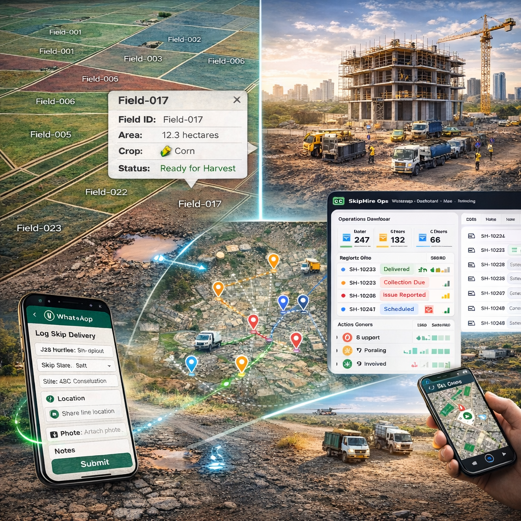
f2dSmartSurvey
Intelligent field data collection and asset inspections—GPS-linked records, photos, smart forms, offline capture, and a dashboard for maps and exports.
f2dScout
Turn WhatsApp into a structured operations system—guided flows with GPS + photos for drivers/teams residents or general public. Includes a live dashboard and map visibility.
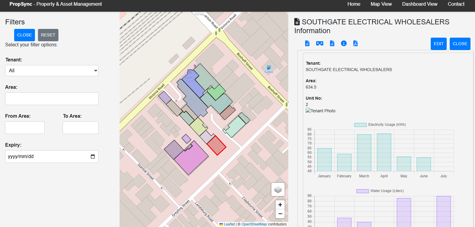
PropTech Ops
A geospatial-first operating layer for malls and property portfolios—spaces, tenants, services, compliance, and maintenance in one system.
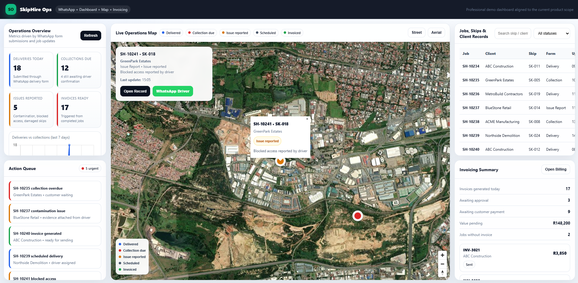
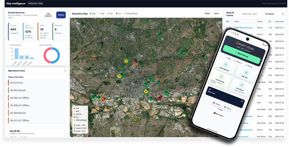
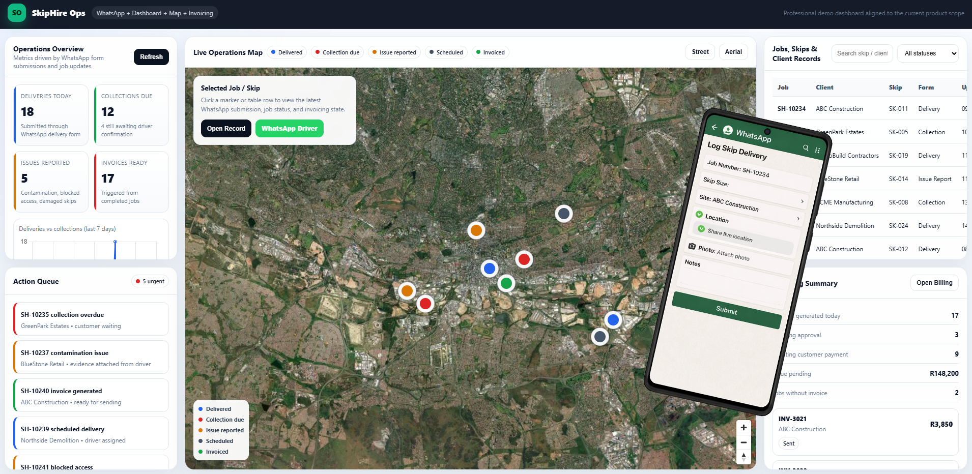
Skip Hire - f2dSCOUT
Manage deliveries, collections, skip locations, proof of delivery, dashboard reporting, web-map visibility, and invoicing in one platform built specifically for skip hire companies.
How it works in your operation
From field capture to live visibility and automated outputs—without manual re-entry, admin lag, or fragmented systems.

Capture in the field
Drivers, technicians, and field teams capture structured data on-site using mobile forms, WhatsApp, maps, photos, and GPS-linked inputs.

Sync instantly
Every record flows into a central system in real time—or syncs automatically when connectivity returns—ready for operations, reporting, and review.
See everything live
Monitor jobs, assets, deliveries, inspections, and exceptions through live dashboards, maps, statuses, and location-aware operational views.
Outputs happen automatically
Delivery confirmations, reports, invoices, compliance packs, exports, and system updates are generated from the same field data—without duplicate admin.
Built for unreliable field conditions, live operations, and clean downstream data
FieldToDesk solutions are designed to keep capture reliable, enforce quality at the point of collection, and produce spatially usable data from day one.
Offline-first capture
Keep field teams moving even in low-signal and no-signal environments.
- Store records locally on device
- Sync automatically when connected
- Reduce missed jobs and delayed submissions
Quality controls at source
Validate required inputs before bad data reaches operations, finance, or compliance workflows.
- Required fields, rules, and checks
- GPS, photo, and timestamp verification
- Less cleanup, fewer back-office corrections
GIS and analytics ready
Turn field activity into structured, location-aware data ready for dashboards, mapping, reporting, and integration.
- Clean exports for spatial workflows
- Map-ready operational records
- Reliable inputs for reporting and automation
Built for Field Operations, Location Intelligence, and Automated Delivery
Every solution is designed to capture reliable data at source, connect it to place, and turn it into live operational visibility and downstream outputs.
Field data capture
Fast, structured capture for crews, drivers, inspectors, and technicians using mobile forms, guided workflows, and low-friction interfaces.
Offline sync
Keep capture moving in poor-signal environments, then sync automatically when connectivity returns—with traceable, reliable data flow.
Maps, GPS & spatial workflows
Capture, monitor, and manage location-aware operations using maps, coordinates, site context, routes, and GIS-ready data structures.
Photos, files & proof of work
Attach photos, signatures, scans, and supporting documents with timestamps, metadata, and audit-ready linkage to each field event.
Validation & exception control
Apply rules, required evidence, review steps, and exception handling so bad data is stopped before it reaches operations or reporting.
Dashboards, reports & integration
Turn field activity into live dashboards, automated outputs, exports, and connected data flows into ERP, GIS, BI, and client systems.
Proven systems you can subscribe to — and custom builds when your workflow needs more
FieldToDesk gives you access to production-ready field systems, operational apps, and geospatial workflows already in use — with the option to commission custom solutions where your process, data model, or delivery requirements demand something tailored.
Ready-to-use subscription products
Access software that is already built, field-tested, and ready to deploy faster than a ground-up project.
Custom systems where needed
Commission bespoke workflows, dashboards, capture tools, and integrations when your operation cannot be forced into a generic product.
Field data that becomes operational intelligence
Every field event can become structured, location-aware data for live visibility, downstream actions, reporting, and client deliverables.
Faster rollout with less reinvention
Start from proven components, repeatable patterns, and working operational models instead of wasting time rebuilding the basics.
Proof, traceability, and cleaner outputs
Capture GPS, photos, timestamps, forms, files, and status changes in one system so reporting, compliance, and dispute handling become simpler.
A platform that grows with your operation
Start with a subscription product, extend with custom modules, and connect new workflows over time without replacing everything later.
Available as Subscription Products, custom delivery, or a hybrid of both.
Some clients need a live product they can subscribe to immediately. Others need a custom operational system shaped around their field process, data rules, reporting outputs, and integration requirements. FieldToDesk supports both.
Built for field-heavy operations that depend on location, proof, and fast decisions
FieldToDesk is most valuable where work happens on the ground, teams move across sites, and the office needs live, structured, location-aware data.
Logistics, collections & deliveries
Capture proof of service, delivery events, site notes, GPS, photos, and exceptions without slowing down drivers or dispatch.
- Proof of delivery
- Route and site event tracking
- Exception capture in the field
Inspections, audits & compliance
Standardise inspections with required evidence, structured forms, review controls, and traceable records tied to place and time.
- Checklist enforcement
- Photo and document evidence
- Audit-ready outputs
Asset, infrastructure & site operations
Track field activity across sites, assets, and service areas with map-linked records, live status visibility, and structured outputs.
- Site-based job tracking
- Asset condition updates
- Location-aware workflows
Survey, GIS & spatial data collection
Collect map-ready field data that flows cleanly into GIS, analytics, reporting, and downstream spatial workflows.
- Point, line, and polygon capture
- GIS-ready exports
- Spatial QA workflows
Service teams & field technicians
Give technicians a clear workflow for jobs, status updates, site evidence, and follow-up actions without admin-heavy reporting.
- Job completion evidence
- Repeatable service workflows
- Cleaner handoff to office teams
Operations that outgrow spreadsheets
Replace fragmented admin, delayed updates, and disconnected field records with a live operating layer built around real-world activity.
- Less manual re-entry
- Better operational visibility
- Faster reporting and outputs
Questions buyers ask before they commit
Clear answers on subscription products, custom builds, data ownership, offline operation, and integrations.
Talk to us about your geospatial roadmap
Tell us what happens in the field and what the office needs to produce. We’ll recommend the fastest path: subscribe to an existing system, extend it, or commission a custom build.
What to include
- Industry + workflow (deliveries, inspections, assets, surveys)
- What needs proof (GPS, photos, signatures, timestamps)
- Outputs required (reports, invoices, compliance packs, exports)
- Integrations (ERP, GIS, BI, storage)